Wednesday, November 11, 2015

Leaving the turtles behind...Adios!

This is it, folks. The final leg of the journey.
After sending the turtles to their certain death out into the ocean to enjoy life, we continue along the coast, first arriving at Lazaro Cardenas. A large, growing port city, Lazaro Cardenas is playing a very IMPORTant role in US trade:

  • Lázaro Cárdenas is home to a deepwater seaport that handles container, dry bulk, and liquid cargo. The port also exports automobiles from various Mexican assembly plants to markets in southeast Asia and South America. The port handled 1.24 million TEU in 2012 and is expanding to a capacity of 2.2 million TEU annually. Cargo moves to and from the port by road and rail equally, with rail service provided exclusively by Kansas City Southern de México. The port is expected to become a major container facility due to congestion at the U.S. ports of Los Angeles and Long Beach and its relative proximity to major cities such as Chicago, Kansas City, and Houston. In preparation for the port's increased capacity, railway and highway infrastructure running north–south through the center of Mexico has been upgraded to handle the anticipated increase in volume of goods bound for the United States using this transportation corridor. If a proposed government-backed Pacific port is built at Punta Colonet, Baja California, goods flowing to U.S. states like Arizona and Nevada could bypass the congested Los Angeles region with closer access those markets, providing increased competition with Lázaro Cárdenas.
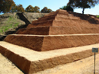
Since we're here, let's stop at La Soledad de Maciel archeological site, located near the town of Petatlan, Mexico. This site, recently (2000) expanded and is considered to be a significant find in establishing Mesoamerican chronology (source).


The small village of Tecpan de Galeana will be our final pause before reaching our destination. When I saw this image on the town's official website, I thought that was being used to indicate some sort of spa/resort/meditation center...but that's not the case at all. Maybe I need to brush up on my Spanish?
According to Google Translate feature, what it really means is: this glif..."Represents the municipality and the city; It is a hieroglyph, interpreted in its generic sense, meaning "where the ruling queen." It has a picture in a "T" column symbolizing unity; some steps that can be interpreted as different degrees of activity in which the family is based on common progress. In general, the symbolism gives identity to their history, culture and traditions."

I recall times from my youth when as a family we would watch cliff divers in Acapulco as they were showcased on ABC's Wide World of Sports. Remember that show? "Spanning the globe, to bring you a constant variety of sport. The thrill of victory, and the agony of defeat."
My last tid-bit will be about the cliff divers. "Another enigmatic attraction at Acapulco are the La Quebrada Cliff Divers. The tradition started in the 1930s when young men casually competed against each other to see who could dive from the highest point into the sea below. Eventually, locals began to ask for tips for those coming to see the men dive. Today the divers are professionals, diving from heights of forty meters into an inlet that is only seven meters wide and four meters deep, after praying first at a shrine to the Virgin of Guadalupe. On December 12, the feast day of this Virgin, freestyle cliff divers jump into the sea to honor her. Dives ranges from the simple to the complicated and end with the "Ocean of Fire" when the sea is lit with gasoline, making a circle of flames which the diver aims for. The spectacle can be seen from a public area which charges a small fee or from the Hotel Plaza Las Glorias/El Mirador from its bar or restaurant terrace.

For more pictures of Acapulco (get out your calendars...you'll want to go!), try this link, this one, or lastly this one. (note: i have NO affiliation with any of these links).

Thank you for following along on this blog. I hope that it has been entertaining and a bit informative. WALK ON!
Tuesday, November 3, 2015

Leaving Mazatlan, Mexico

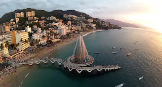
From one resort city to another, we'll get to Puerto Vallarta in no time. My earliest recollections of hearing this city's name come from game shows during the 80's. "You've won an all-expense-paid trip to PUERTO VALLARTA MEXICO!!!!!" Can't you just hear it now?


Perhaps the most interesting thing that I learned about Puerto Vallarta is that "Guadalajara and Acapulco were common vacation destinations for gay men and lesbians from Mexico City and, especially, the United States and Canada in the 1980s and 1990s. However, since that time, Puerto Vallarta has developed into Mexico's premier resort town as a sort of satellite gay space for its big sister Guadalajara, much as Fire Island is to New York City and Palm Springs is to Los Angeles. It is now considered the most welcoming and gay-friendly destination in the country, dubbed the "San Francisco of Mexico." Previously quite conservative, the municipal government has become increasingly supportive in recognizing and accepting the LGBT tourism segment and in supporting LGBT events such as Vallarta gay pride celebrations which launched in 2013 and is now held annually to coincide with US Memorial Day weekend. It boasts a gay scene, centered in the city's south-side Zona Romántica, of hotels and resorts as well as many bars, nightclubs, and a gay beach on the main shore. Puerto Vallarta has been cited as the number one gay beach destination in Latin America, with city officials claiming a 5% tourism increase in 2013."

Next stop, Tecoman.The main economic activities of the area are:
  • Agriculture: Limes, coconuts, tamarind, mango and bananas.
  • Livestock: Cattle, pigs, sheep, goats and apiculture.
  • Industrial: Citrus and coconut agroindustry
  • Mining: Dolomite, limestone and silver
Tecoman is known as "the World's Lime Capital." (source)


I couldn't have been luckier with the location for tonight's stop over. Colola, Mexico. According to LonelyPlanet, "An estimated 70% of the world’s population of black sea turtles, along with olive ridley and leatherback turtles, lay their eggs on the long flat sands of Playa Colola." How cool is that? MUCHO~!


Several international organizations come together to support efforts to make sure the turtle babies make it to the ocean. Most participants spend their time in encampments such as these grass huts.


If  you are interested in learning more about these efforts, please visit these sites (I have no affiliation with any of these websites/programs).


Headed for the Coast!

Our morning leaving Querobabi heads us in the direction of the Gulf of California coast and the resort city of Guaymas. It is about time that we get out of the desert for a while and enjoy the COAST. Here's where we're headed:
Guaymas, Mexico
Guaymas "is a city located in Guaymas Municipality in the southwest part of the state of Sonora in northwestern Mexico. The city is located 72miles south of the state capital of Hermosillo, and 242 miles from the U.S. border, and is the principal port for the state. The municipality is located in the Sonora Desert and has a hot, dry climate and 72 miles of beaches."
Sounds great to me! The US has a little history nearby, too. "The Guaymas-Empalme station for space observations is about six miles east of Empalme, Sonora, adjacent to Mexican Federal Highway No. 15. It is operated by the Mexican Space Agency. As a major link in the NASA Manned Space Flight Network, the Guaymas Tracking Station, built in 1961, played a key role in tracking American manned space flights in the Mercury, Gemini, and Apollo programs through Apollo 13. The U.S. discontinued its use on November 30, 1970 due to changes in the Apollo mission profile which no longer required the Guaymas station. Equipment designed especially for support of the Apollo program was removed, but other equipment was left for support of Mexican space activities and future programs of mutual interest to Mexican scientists and NASA." (source).

The next town of note that we come to is Navojoa. The only information that I could find on this town referred to it as "liquor country." So there's that...

Our originally planned destination city for this leg, Navolato, Sinaloa, Mexico, leaves me pushing us to go farther and not actually stop in Navolato. I won't go into the reasons here, but feel free to seek it out on google images...


Let's stay in Mazatlan, shall we? Si, we shall. Although the first Europeans to take up residence were Spanish, they didn't have the most influence on the city's history. "Mazatlán is Nahuatl word meaning "place of deer". The city was founded in 1531 by an army of Spaniards and indigenous settlers. By the mid-19th century a large group of immigrants had arrived from Germany. These new citizens developed Mazatlán into a thriving commercial seaport, importing equipment for the nearby gold and silver mines."
Let us bask in the glow of these wonderful pictures as we enjoy some great food and rest.


Get some sleep...